BaseDog.it
Magic Site
main_900-17
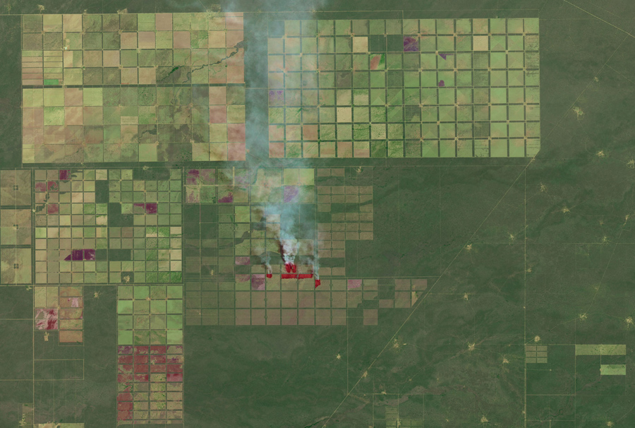
The chaco forests of northern Argentina spread across a vast outwash plain in the center of South America. Shrubs and hardwood forests thrive in the semi-arid region. For many years, puestos—small settlements centered around water sources—dotted the landscape. But in the past decade, large-scale farm and ranch operators have cleared broad swaths of the chaco to make way for livestock and crops raised on an industrial scale. In fact, an analysis of data collected by several Landsat satellites suggests that Argentina’s chaco faces one of the fastest tropical deforestation rates in the world. On October 15, 2015, the Operational Land Imager (OLI) on Landsat 8 captured this false-color image of fields, forests, and puestos in the Salta province of northern Argentina. The fields, most of which appear to be fenced, are arranged in a grid pattern. Fires are actively burning in a few sectors of the grid, likely lit by land managers trying to clear shrubs and trees to make room for livestock, timber, or crops. Fresh burn scars are dark brown; older burn scars are lighter brown. Over time, burned areas become light green and eventually dark green. (NASA Earth Observatory, Joshua Stevens, using Landsat data from the USGS)